


Mysterious Alignment
Another puzzle is mysterious alignment of world's ancient sites. Easter Island is exactly aligned along a straight line around the center of the Earth, with the Nazca lines, Ollantaytambo and the Great Pyramid of Egypt. Other world wonders that are within one tenth of one degree of this alignment include: Perseopolis, the capital city of ancient Persia; Mohenjo Daro, the ancient capital city of the Indus Valley; the Oracle of Zeus-Amon at Siwa; and the lost city of Petra. The Ancient Sumarian city of Ur and Angkor temples in Cambodia and Thailand are within one degree of latitude of this alignment.
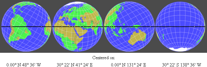
The alignment of these sites is easily observable on a globe of the Earth with a horizon ring. If you line up any two of these sites on the horizon ring, all of the sites will be right on the horizon ring. 3-D world atlas software programs can also draw this line around the Earth. Start on the Equator, at the mouth of the Amazon River, at 48° 36' West Longitude; go to 30° 22' North Latitude, 41° 24' East Longitude, in the Middle East, which is the maximum latitude the line touches; then go to the Equator at 131° 24' East Longitude, near the Northwest tip of New Guinea; then to 30° 22' South Latitude, 138° 36' West Longitude, in the South Pacific; and then back to 48° 36' West Longitude, at the Equator.
Centered on:
0.00° N
48° 36' W
30° 22' N
41° 24' E
0.00° N
131° 24' E
30° 22' S
138° 36' W
The circumference of this line around the center of the Earth is 24,892 miles. Along this line, the great circle distance from the Great Pyramid to Ollantaytambo is 7,472 miles, 30.0% of the circumference. Ollantaytambo is 2,579 miles from Easter Island, 10.3%. Easter Island is 10,096 miles from Angkor Wat, 40.6%. Angkor Wat is 2,490 miles from Mohenjo Daro, 10.0%. Mohenjo Daro is 2255 miles from from the Great Pyramid, 9.1%. In addition to calculating the distances between these sites as a percentage of the circumference of the Earth, the distances may also be calculated in degrees of the 360° circumference, by multiplying the percentage by 3.6. For example, the Great Pyramid is 108° away from Ollantaytambo. Near Ollantaytambo, Machupicchu is within one quarter of a degree and Cuzco is within one third of a degree of the alignment.
http://www.world-mysteries.com/new_mpl.shtml
============================================
Buat yang kurang bisa bahasa Inggris, jadi intinya jika ditarik garis lurus sesuai gambar di atas dan dibawah ini, Pulau Paskah berada pada garis yang sama dengan Nazca Lines, Ollantaytambo, Piramida Mesir, Perseopolis (ibukota Persia), Mohenjo Daro, the Oracle of Zeus-Amon di Siwa, kota Petra, kota Ur dan kuil Angkor di Kamboja. Jadi keajaiban masa lalu terhubung melalui satu garis lurus. Ajaib bukan??
Karya tulis selengkapnya bisa dibaca di http://home.hiwaay.net/~jalison/index.html panjang sekali, dan disitu juga ada tentang ibukota negara yang juga terhubung oleh satu garis lurus.
-
06-12-08, 17:21 #1


- Join Date
- Aug 2008
- Location
- Menara Jakarta
- Posts
- 1,890
- Points
- 2,829.71
Thanks: 0 / 7 / 7 The Prehistoric Alignment of World Wonders
Quote of the week:
The Prehistoric Alignment of World Wonders
Quote of the week:

"Indonesia is on the move, get on board." Forbes Asia
"The optimist proclaims that we live in the best of all possible worlds; and the pessimist fears this is true." James Branch Cabell
Vote for Komodo National Park:
http://www.new7wonders.com/nature/en/vote_on_nominees/
-
11-12-08, 10:07 #2


- Join Date
- Feb 2008
- Location
- 2 StEpS From You @_@"
- Posts
- 881
- Points
- 1,109.60
Thanks: 2 / 0 / 0
waduh ksian gx ad yg comment @_@"
jd mksdnya pulau paskah itu kayak ad hubungan sama yg di atas?
weleh2 kurang ngerti saya <<<---- orang bodohWith SworD , Spear , BOw........
I Will Kill Your BorRing
-
11-12-08, 12:42 #3
- Join Date
- Aug 2008
- Location
- Menara Jakarta
- Posts
- 1,890
- Points
- 2,829.71
Thanks: 0 / 7 / 7
Maksudnya, jadi intinya jika ditarik garis lurus sesuai gambar di atas dan dibawah ini, Pulau Paskah berada pada garis yang sama dengan Nazca Lines, Ollantaytambo, Piramida Mesir, Perseopolis (ibukota Persia), Mohenjo Daro, the Oracle of Zeus-Amon di Siwa, kota Petra, kota Ur dan kuil Angkor di Kamboja. Jadi keajaiban masa lalu terhubung melalui satu garis lurus. Ajaib bukan?? Originally Posted by Shinzo_Dame
 Quote of the week:
"Indonesia is on the move, get on board." Forbes Asia
"The optimist proclaims that we live in the best of all possible worlds; and the pessimist fears this is true." James Branch Cabell
Vote for Komodo National Park:
http://www.new7wonders.com/nature/en/vote_on_nominees/
-
11-12-08, 12:47 #4

- Join Date
- Sep 2008
- Location
- Rumahku Istanaku Status: Member jelata
- Posts
- 366
- Points
- 606.40
Thanks: 0 / 1 / 1
wow keren, tapi kok kesannya agak maksa yah? melihat gambar globenya seolah sengaja dimiringin.
-
12-12-08, 11:59 #5

- Join Date
- Dec 2006
- Location
- BeYoNd YoUr ImAgInaTioN!!
- Posts
- 398
- Points
- 458.40
Thanks: 0 / 0 / 0
namanya juga keajaiban...bukan sekedar kebetulan.
Spoiler untuk IDGS Story Character :
-
13-12-08, 05:59 #6

- Join Date
- Dec 2007
- Location
- where the mud is blow up
- Posts
- 1,673
- Points
- 2,006.30
Thanks: 1 / 0 / 0
@mizuniverse...
ya kudu di miringin, kan bumi bentuknya bulat walaupun ga 100%...
tp diliat dari garis LS dan LU nya aja uda tau... aneh bener ya??
-
13-12-08, 07:34 #7

- Join Date
- Nov 2008
- Posts
- 113
- Points
- 185.20
Thanks: 0 / 0 / 0
WOW, HEBAT! Mungkin saja sebenarnya dulu teknologi mereka sudah maju, sudah saling berhubungan. Contoh terhebat adalah Piri Reis Map, penemuan peta yang menggambarkan dunia dengan benar padahal saat itu belum ada teknologi satelit. Mungkin fenomena ini bisa menjelaskan itu juga.
Il faut plus d'amour dans le monde.
-
13-12-08, 10:06 #8
- Join Date
- Aug 2008
- Location
- Menara Jakarta
- Posts
- 1,890
- Points
- 2,829.71
Thanks: 0 / 7 / 7
A NEW LOOK AT AN OLD DESIGN
THE PREHISTORIC ALIGNMENT OF WORLD WONDERS
JIM ALISON
PART I - THE GREAT CIRCLE
Great circles are straight lines that go all the way around the center of the earth. The equator is a great circle. Meridians of longitude that cross over the north and south poles are also great circles. For every location on a great circle, it's antipodal location is also on the circle. Other than the equator itself, any great circle crosses the equator at two antipodal locations, 180° apart. Other than the equator and meridians of longitude that run due north and south, any great circle reaches it's maximum latitudes at two locations that are 90° of longitude east and west of the two locations where the great circle crosses the equator.
Easter Island, Nazca, Ollantaytambo, Paratoari, Tassili n'Ajjer and Giza are all aligned on a single great circle. Additional ancient sites that are located within one tenth of one degree of this great circle include Petra; Perseopolis; Khajuraho; Pyay, Sukothai and Anatom Island.
Near Ollantaytambo, Machupicchu and Cuzco are within one quarter of a degree. The Oracle at Siwa in the western Egyptian desert is within one quarter of a degree. In the Indus Valley, Mohenjo Daro and Ganweriwala are within one quarter of a degree. The ancient Sumerian city of Ur and Angkor temples in Cambodia and Thailand are within one degree of the great circle. The Angkor temple at Preah Vihear is within one quarter of a degree.
This circle crosses over the source and the mouth of the Amazon, the dividing line between upper and lower Egypt, the mouth of the Tigris-Euphrates, the Indus River and the Bay of Bengal near the mouth of the Ganges. The circle also crosses over a number of areas of the world that are largely unexplored, including the Sahara Desert, the Brazilian Rainforest, the highlands of New Guinea, and underwater areas of the North Atlantic Ocean, the South Pacific Ocean and the South China Sea.
The alignment of these sites is easily observable on a globe of the earth with a horizon ring. Aligning any two of these sites on the horizon ring will align all of these sites on the ring. 3-D world atlas software programs will also draw this great circle around the earth. The four images below are centered on the two locations where the great circle crosses the equator and the two locations where the great circle reaches it's maximum latitudes. The circle crosses over the equator at 48° 36' west longitude and 131° 24' east longitude. The maximum latitude of the circle is 30° 22' north latitude at 41° 24' east longitude and 30° 22' south latitude at 138° 36' west longitude.
All great circles have two antipodal axis points. The two axis points for the equator are the north and south poles. Every point along the equator is equally distant at 90°, or one quarter of the circumference of the earth, from the north and south poles. For any great circle, the distance from the axis points to any point along the circle is one quarter of the circumference of the earth. For any great circle other than the equator, the longitude of the axis points are 90° east and west of the two points where the great circle crosses the equator.
Great circles that run due north-south along meridians of longitude have their axis points on the equator, 90° of longitude east and west of the points where the meridian circle crosses the equator and 90° of latitude from the poles where meridian circles reach their maximum latitudes. The distance from the axis points to any point along a meridian circle is one quarter of the circumference of the earth, but 90° of longitude from the axis point to the point where the meridian circle crosses the equator is 6,225 miles, while 90° of latitude from the axis point to the maximum latitude of the meridian circle at the poles is 6,215 miles. This is because the polar circumference of the earth is 24,860 miles, while the equatorial circumference is 24,901 miles, due to the bulge of the earth at the equator and the flattening of the earth at the poles.
Our modern system of calculating degrees of latitude from the equator to the poles is based on the north-south angular change along the surface of the earth. As a result, degrees of latitude are slightly longer at the poles, where the earth is flatter, and slightly shorter at the bulge of the equator. For great circles other than the equator and other than meridian circles, the north-south distance from the axis points to the great circle crosses over the pole in one direction, while it crosses over the equator in the other direction. As a result, the latitude of the axis points must be adjusted slightly to compensate for the longer distance of degrees of latitude at the poles and the shorter distance of degrees of latitude at the equator.
The two axis points for the great circle illustrated above are located at 59° 53' north latitude and 138° 36' west longitude and at 59° 53' south latitude and 41° 24' east longitude. The southern axis point is in deep water approximately 500 miles from the coast of Antarctica. The northern axis point is in the northwestern corner of Canadian British Columbia on a glaciated ridge line approximately 6,500 feet above sea level. The circumference of this great circle is 24,892 miles. This is slightly less than the equatorial circumference of the earth, but closer to the equatorial than the polar circumference because the maximum latitude of the great circle is closer to the equator than the poles, and because most of the shortening of the polar circumference is due to the flattening of the earth near the poles.
The chart below lists the distance of each site from the great circle and the distance of each site from the northern axis point. There are slight variations in the distance from the axis point to the great circle depending on whether the route from the axis point to different locations along the great circle crosses over the equator or polar regions. The mean distance from the axis point to the great circle is 6,218 miles.
Latitude Longitude To Great Circle: To Axis Point:
Giza 29° 59' N 31° 09' E 0 miles 6.219 miles
Siwa 29° 14' N 25° 31' E 10 miles 6,231 miles
Tassili n'Ajjer 26° 32' N 9° 50' E 0 miles 6,218 miles
Paratoari 12° 48' S 71° 25' W 0 miles 6,219 miles
Ollantaytambo 13° 15' S 72° 16' W 0 miles 6,220 miles
Machupicchu 13° 06' S 72° 35' W 15 miles 6,206 miles
Nazca 14° 42' S 75° 06' W 0 miles 6,221 miles
Easter Island 27° 06' S 109° 20' W 0 miles 6,221 miles
Aneityum Island 20° 10' S 169° 48' E 8 miles 6,230 miles
Preah Vihear 14° 24' N 104° 40' E 25 miles 6,241 miles
Sukhothai 17° 01' N 99° 42' E 5 miles 6,226 miles
Pyay 19° 15' N 95° 05' E 5 miles 6,213 miles
http://home.hiwaay.net/~jalison/index.html
Masih ada 12 bab lagi, bisa dibaca sendiri di http://home.hiwaay.net/~jalison/index.htmlQuote of the week:
"Indonesia is on the move, get on board." Forbes Asia
"The optimist proclaims that we live in the best of all possible worlds; and the pessimist fears this is true." James Branch Cabell
Vote for Komodo National Park:
http://www.new7wonders.com/nature/en/vote_on_nominees/
-
29-12-08, 05:48 #9

- Join Date
- Nov 2008
- Location
- Jogja - Surabaya - Jogja
- Posts
- 193
- Points
- 228.90
Thanks: 1 / 1 / 1
Wah, kebetulan, saya baru bikin thead 10 peradaban kota yang hilang. Jadi ini ya misterinya. Originally Posted by Menara_Jakarta
Awalnya saya juga heran, mengapa peradaban manusia seindah itu dan sebanyak itu bisa punah dan terlupakan begitu saja. Ternyata mereka masih memiliki hubungan seperti itu.
"misteri - misteri juga memiliki suatu hubungan yang juga berupa misteri"
-
29-12-08, 21:32 #10
- Join Date
- Aug 2008
- Location
- Menara Jakarta
- Posts
- 1,890
- Points
- 2,829.71
Thanks: 0 / 7 / 7
Selain wonders juga ada lagi, seperti ibukota-ibukota negara dunia. Originally Posted by the_Quirk
Quote of the week:
"Indonesia is on the move, get on board." Forbes Asia
"The optimist proclaims that we live in the best of all possible worlds; and the pessimist fears this is true." James Branch Cabell
Vote for Komodo National Park:
http://www.new7wonders.com/nature/en/vote_on_nominees/
-
31-12-08, 15:40 #11


- Join Date
- Jul 2007
- Location
- PertiGa'an Deket SMP Kha-ShoeS
- Posts
- 521
- Points
- 677.90
Thanks: 1 / 1 / 1
betul emang agak maksa banget itu seh jakarta bisa aj disejajarin sama kutub selatan
-
01-01-09, 20:59 #12


- Join Date
- Dec 2006
- Location
- Underground
- Posts
- 9,263
- Points
- 16,021.75
Thanks: 408 / 1,962 / 935
keanehan garis peta...
seperti Pulau Easter (Pulau Paskah) di kepulauan Pasifik, piramid di Mesir, garis Nasca di Peru, kuil Angkor Watt di Kambodia dan lain sebagainya. Ketika beberapa lokasi kunci ini dipetakan, terbentuk sebuah garis lingkaran yang nyaris sempurna, menyuguhkan sebuah misteri yang belum bisa terpecahkan melalui penyelidikan arkeologi saat ini.
Banyak orang mengatakan bahwa garis hubungan tersebut menggambarkan bahwa masyarakat purba telah memiliki sebuah pengetahuan yang jauh lebih besar daripada kepercayaan sekarang yang dianut secara meluas dan diturunkan oleh para leluhur kita. Sedangkan lainnya mengatakan bahwa pusat lingkaran yang ditemukan di sebelah tenggara Alaska ini, mungkin menggambarkan dimana letak kutub bumi sebelum mereka bergeser ke lokasi sekarang berada.
-
02-01-09, 14:43 #13

- Join Date
- Feb 2008
- Location
- P.R.L 412, Club non homo IDGS!
- Posts
- 1,840
- Points
- 2,228.40
Thanks: 0 / 0 / 0
btw pulau paskah itw ap kk? maklum, sya org awam ne
Anti-****, Anti-Indogaymers, Anti cowok suka cowok, Anti sex dgn sesama jenis, tidak ad yang **** disini!
Bergabunglah dgnSpoiler untuk ANTI **** :
-
08-01-09, 15:10 #14
- Join Date
- Aug 2008
- Location
- Menara Jakarta
- Posts
- 1,890
- Points
- 2,829.71
Thanks: 0 / 7 / 7
Pulau Paskah (bahasa Polinesia: Rapa Nui, bahasa Spanyol: Isla de Pascua) adalah sebuah pulau milik Chili yang terletak di selatan Samudra Pasifik. Walaupun jaraknya 3.515 km sebelah barat Chili Daratan, secara administratif ia termasuk dalam Provinsi Valparaiso. Pulau Paskah berbentuk seperti segitiga. Daratan terdekat yang berpenghuni ialah Pulau Pitcairn yang jaraknya 2.075 km sebelah barat. Luas Pulau Paskah sebesar 163,6 km². Menurut sensus 2002, populasinya berjumlah 3.791 jiwa yang mayoritasnya menetap di ibukota Hanga Roa. Pulau ini terkenal dengan banyaknya patung-patung (moai), patung berusia 400 tahun yang dipahat dari batu yang kini terletak di sepanjang garis pantai. Originally Posted by PDSP
 Quote of the week:
"Indonesia is on the move, get on board." Forbes Asia
"The optimist proclaims that we live in the best of all possible worlds; and the pessimist fears this is true." James Branch Cabell
Vote for Komodo National Park:
http://www.new7wonders.com/nature/en/vote_on_nominees/
-
11-01-09, 11:13 #15

- Join Date
- Jun 2007
- Location
- jogja party town
- Posts
- 259
- Points
- 306.40
Thanks: 0 / 0 / 0
emang ada apa di pulau nya ? ada hubungannya ma hari paskah ? Originally Posted by Menara_Jakarta
LUPH LUPH LUPH LUPH LUPH LUPH

A L W A Y S


Share This Thread